Simple GPS System Created By Grain Farmer
 ✖  |
I looked into GPS guidance back in 2005 when the first light bar systems showed up on the market, says Alberta farmer Johannes Heupel. We have a lot of bush, sloughs and rolling hills, so those systems didnt work. I developed a simple VB application myself using my Garmin hunting GPS, and that was just marginally better. A year later I developed another system that worked much better, and Ive improved it every year since, even adding autosteer in 2014.
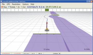
Today Heupels system, which he markets to customers around the world, is called FarmerGPS. It uses proprietary software, a standard PC laptop or tablet with the Windows operating system, a 12V/110V converter to power the laptop, a Novatel GPS receiver, interface hardware, cabling, mounting hardware and the FarmerGPS software. Those 7 components cost about $1,800 to $2,000, far less than other systems which cost thousands more. He sells his software alone for $399.
Its an easy system to install and set up, says Jim Walsh, a North Dakota farmer who runs a FarmerGPS system. My 76-year-old dad cant see the watch on his arm, but he can easily run the sprayer because of the 14-in. laptop screen, Walsh says. Iowa farmer Joe Bahe says the FarmerGPS system eliminated spray skips for him because the on-screen mapping showed exactly where he had sprayed. It was so simple I set everything up in less than a day, and on the second day I showed my dad how to run it in 2 minutes, with no problems, Bahe says.
In addition to his Alberta grain farm, Heupel is a trained electrical engineer and computer programmer who built his first computer in 1983. Those combined skills produced his efficient and low-cost guidance system. The beauty of the FarmerGPS system is that it does all the things that more expensive name brand products do at a much lower price on standard hardware, says Heupel. FarmerGPS reduces overlap on tillage, planting and spraying, and also minimizes gaps. The mapping system verifies field coverage on the computer screen and through printable reports. It also marks areas or points in a field where weeds might be a problem, or rocks need to be picked.
I have customers around the world, and the system keeps growing in functionality, says Heupel, who adds new features during the winter months when hes less busy with farming. In 2013 he added FreePilot autosteer, and in 2014 he worked on Bluetooth, networking and yield/moisture integration for Claas Lexion combines.
Heupel says accuracy depends entirely on the GPS receiver used, with Waas-type receivers providing 6-in. pass-to-pass. Some customers use RTK with 1 to 2-in. accuracy. In 2013 he used planting maps from the system in his Claas Lexion combine so he could tell where two types of wheat were seeded in the same field. That feature allowed him to differentiate the harvest and keep varieties separate. In the winter of 2014 he tested the autosteer on the same combine and called it very successful. He hopes to market that variation in time for the 2014 harvest.
Contact: FARM SHOW Followup, Johannes Heupel, Agra-GPS Ltd., Box 2585, Stony Plain, Alberta, Canada T7Z 1X9 (ph 780 990-4052; farmergps@hotmail.com). You can download the software at www.farmergps.com for a free trial.
Click here to download page story appeared in.
Click here to read entire issue
Simple GPS System Created By Grain Farmer COMPUTERS I looked into GPS guidance back in 2005 when the first light bar systems showed up on the market says Alberta farmer Johannes Heupel We have a lot of bush sloughs and rolling hills so those systems didnt work I developed a simple VB application myself using my Garmin hunting GPS and that was just marginally better A year later I developed another system that worked much better and Ive improved it every year since even adding autosteer in 2014 Today Heupels system which he markets to customers around the world is called FarmerGPS It uses proprietary software a standard PC laptop or tablet with the Windows operating system a 12V/110V converter to power the laptop a Novatel GPS receiver interface hardware cabling mounting hardware and the FarmerGPS software Those 7 components cost about $1 800 to $2 000 far less than other systems which cost thousands more He sells his software alone for $399 Its an easy system to install and set up says Jim Walsh a North Dakota farmer who runs a FarmerGPS system My 76-year-old dad cant see the watch on his arm but he can easily run the sprayer because of the 14-in laptop screen Walsh says Iowa farmer Joe Bahe says the FarmerGPS system eliminated spray skips for him because the on-screen mapping showed exactly where he had sprayed It was so simple I set everything up in less than a day and on the second day I showed my dad how to run it in 2 minutes with no problems Bahe says In addition to his Alberta grain farm Heupel is a trained electrical engineer and computer programmer who built his first computer in 1983 Those combined skills produced his efficient and low-cost guidance system The beauty of the FarmerGPS system is that it does all the things that more expensive name brand products do at a much lower price on standard hardware says Heupel FarmerGPS reduces overlap on tillage planting and spraying and also minimizes gaps The mapping system verifies field coverage on the computer screen and through printable reports It also marks areas or points in a field where weeds might be a problem or rocks need to be picked I have customers around the world and the system keeps growing in functionality says Heupel who adds new features during the winter months when hes less busy with farming In 2013 he added FreePilot autosteer and in 2014 he worked on Bluetooth networking and yield/moisture integration for Claas Lexion combines Heupel says accuracy depends entirely on the GPS receiver used with Waas-type receivers providing 6-in pass-to-pass Some customers use RTK with 1 to 2-in accuracy In 2013 he used planting maps from the system in his Claas Lexion combine so he could tell where two types of wheat were seeded in the same field That feature allowed him to differentiate the harvest and keep varieties separate In the winter of 2014 he tested the autosteer on the same combine and called it very successful He hopes to market that variation in time for the 2014 harvest Contact: FARM SHOW Followup Johannes Heupel Agra-GPS Ltd Box 2585 Stony Plain Alberta Canada T7Z 1X9 ph 780 990-4052; farmergps@hotmail com You can download the software at www farmergps com for a free trial
To read the rest of this story, download this issue below or click
here to register with your account number.