Sensor-Controlled Compaction Ripping
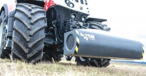 ✖  |
You dont have to till an entire field to get rid of compaction. The Top Soil Mapper from Geoprospectors tells the operator how deep to penetrate as it identifies where the compaction zone is on-the-go. At the same time, the front-mounted sensor on the tractor maps fertility and more across the field.
The technology behind the Top Soil Mapper has been proven in Europe, says Rick Pryor, Geoprospectors. Compaction zones can appear at different depths in the field. It can start at 8 in. or 16. We find the top of the layer. If it is at 6 in. and the layer is 6 in. thick, you only have to rip 13 in. deep.
Initially introduced to the North American market as the Field Scan, it was limited to data gathering. This past year, the Austrian parent company Geoprospectors added the real-time tillage control.
The contact-free sensing technology uses 4 magnetic induction coils to penetrate the soil to different depths. Each coil produces its own data stream. An algorithm uses the data streams to create a 3D profile of the soil, revealing horizontal and vertical variability. Internal sensors gather temperature and pitch/roll/height above ground to ensure accurate data gathering.
When operated about a foot above the ground surface, the Topsoil Mapper measures the soil to a depth of about 44 in. In addition to compaction and fertility zones, the sensor also detects percent of water content in the soil.
Data gathered by the sensor travels to the automatic tillage control (ATC) kit. The kit can be installed on any cultivator or subsoiler with continuous hydraulic depth control. It can be used in either automatic or manual (operator controlled) mode.
ATC was developed and patented by Geoprospector, says Pryor. A PWM (pulse width modulation) valve releases a precise amount of hydraulic fluid to adjust the tillage unit depth.
Pryor notes that the changes in tillage depth in automatic mode can be so subtle as to not be noticed by the operator.
He adds that real time ripping only works with narrow implements and is a full-field effort. However, mapping swathes in the field ahead of tillage or other activities appears to gather sufficient data.
Our customers and I have tried different width swaths, running the sensor every 25, 30 and 40 ft., and we could find no difference, says Pryor. A 40-ft. swath appears to be perfect. The variability of the plow pan is not that extreme that you need full-field data.
The Topsoil Mapper comes with a 3-pt. mount, but can also be installed on a variety of equipment such as side-by-sides, tractors and implements.
Site-specific data can be exported to a laptop computer for collection, immediate analysis and mapping output and control with the Topsoil Visualizer and Topsoil Data Analyzer software. Raw data can be displayed as maps within seconds for on-site action.
Data can also automatically load to the cloud for later use or sharing as the data owner desires.
While the Topsoil Mapper with ATC will appeal to some farmers, it will often be available as a mapping service from retailers and crop consultants. Prepared maps can then be used at the farm with an ATC-equipped tractor and implement.
The Topsoil Mapper is priced at about $25,000 with a software subscription price of about $2,000 a year, says Pryor. A crop consultant customer tells us his system paid for itself in one year.
Contact: FARM SHOW Followup, Geoprospectors Inc., 1776 S Jackson Street, Suite 602, Denver, Colo. 80210 (ph 855 627-7371; rp@geoprospectors.com; www.geoprospectors.com).
Click here to download page story appeared in.
Click here to read entire issue
Sensor-Controlled Compaction Ripping SUBSOILERS You dont have to till an entire field to get rid of compaction The Top Soil Mapper from Geoprospectors tells the operator how deep to penetrate as it identifies where the compaction zone is on-the-go At the same time the front-mounted sensor on the tractor maps fertility and more across the field The technology behind the Top Soil Mapper has been proven in Europe says Rick Pryor Geoprospectors Compaction zones can appear at different depths in the field It can start at 8 in or 16 We find the top of the layer If it is at 6 in and the layer is 6 in thick you only have to rip 13 in deep Initially introduced to the North American market as the Field Scan it was limited to data gathering This past year the Austrian parent company Geoprospectors added the real-time tillage control The contact-free sensing technology uses 4 magnetic induction coils to penetrate the soil to different depths Each coil produces its own data stream An algorithm uses the data streams to create a 3D profile of the soil revealing horizontal and vertical variability Internal sensors gather temperature and pitch/roll/height above ground to ensure accurate data gathering When operated about a foot above the ground surface the Topsoil Mapper measures the soil to a depth of about 44 in In addition to compaction and fertility zones the sensor also detects percent of water content in the soil Data gathered by the sensor travels to the automatic tillage control ATC kit The kit can be installed on any cultivator or subsoiler with continuous hydraulic depth control It can be used in either automatic or manual operator controlled mode ATC was developed and patented by Geoprospector says Pryor A PWM pulse width modulation valve releases a precise amount of hydraulic fluid to adjust the tillage unit depth Pryor notes that the changes in tillage depth in automatic mode can be so subtle as to not be noticed by the operator He adds that real time ripping only works with narrow implements and is a full-field effort However mapping swathes in the field ahead of tillage or other activities appears to gather sufficient data Our customers and I have tried different width swaths running the sensor every 25 30 and 40 ft and we could find no difference says Pryor A 40-ft swath appears to be perfect The variability of the plow pan is not that extreme that you need full-field data The Topsoil Mapper comes with a 3-pt mount but can also be installed on a variety of equipment such as side-by-sides tractors and implements Site-specific data can be exported to a laptop computer for collection immediate analysis and mapping output and control with the Topsoil Visualizer and Topsoil Data Analyzer software Raw data can be displayed as maps within seconds for on-site action Data can also automatically load to the cloud for later use or sharing as the data owner desires While the Topsoil Mapper with ATC will appeal to some farmers it will often be available as a mapping service from retailers and crop consultants Prepared maps can then be used at the farm with an ATC-equipped tractor and implement The Topsoil Mapper is priced at about $25 000 with a software subscription price of about $2 000 a year says Pryor A crop consultant customer tells us his system paid for itself in one year Contact: FARM SHOW Followup Geoprospectors Inc 1776 S Jackson Street Suite 602 Denver Colo 80210 ph 855 627-7371; rp@geoprospectors com; www geoprospectors com
To read the rest of this story, download this issue below or click
here to register with your account number.